GIS Auditing and Mapping
Northwest Edison uses geographic information systems (GIS) for making precision auditing and mapping decisions. We rely on GIS technology to provide an efficient, integrated platform for planning and analysis, workforce automation and situational awareness.
Our company continues to position itself as a leader in the industry, with a vision of expansion throughout the United States.
Proper lighting provides the right quantity of light; it draws attention and promotes safety and security. Bad lighting can do the opposite.
Northwest Edison uses geographic information systems (GIS) for making precision auditing and mapping decisions. We rely on GIS technology to provide an efficient, integrated platform for planning and analysis, workforce automation and situational awareness. By taking full advantage of GIS technology across each project, Northwest Edison is prepared to successfully manage the latest industry challenges.
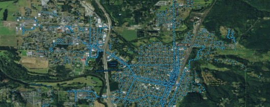
Northwest Edison is an industry trailblazer when it comes to implementing GIS technology solutions for streetlight conversion and retrofit projects. Streetlights present distinct challenges due to their complex geographical nature and the sizeable amounts of data points to manage. In circumstances where streetlights need to be mapped out and data collected, GIS is an invaluable tool.
Without accurate data on existing streetlight inventory from a current GIS audit, it is virtually impossible to properly maintain, repair or upgrade to LED lighting. By utilizing Northwest Edison’s GIS knowledge and expertise, you get precise installation information and pole location, making it easier to pinpoint exactly where future maintenance and repairs are needed.
No guesswork, no unnecessary field verification, no missed or incorrectly marked lights, no problem.
The challenge for many government cities and counties, is managing their network of street lighting fixtures optimally to meet customer expectations and industry compliance regulations. Often, these enterprises still rely on inaccurate paper maps, hand-drawn coordinates or worker recollection on where electrical fixtures are located. Additionally, many times poles are relocated or removed, while the city is billed monthly for these nonexistent structures. Repair and replace electrical utility components more efficiently and realize a significant ROI quickly by investing in GIS utility auditing and mapping services.
Northwest Edison offers specialized experience in GIS auditing, field data acquisition and LED conversion services. With our precision developed utility auditing and mapping services, you can:
- Design and develop more efficient maintenance and repair project planning
- Logically store locations of all street lighting assets
- Get quicker results with accurate location and operational data
- Efficiently operate and manage your entire infrastructure while reducing costs
Northwest Edison’s comprehensive onsite GIS audit will identify the following information:
- The Global Positional System (GPS) of each fixture location
- Fixture type, height, color and mast arm length
- Pole mounting configuration
- Pole number, type, height, color, shape and overall condition
- Bulb type and wattage
- Tag ID numbers
- Street name
- Physical attributes or issues
- Duplicate or shared fixture data